Saturday, December 10, 2011

It Was a Rare Day in November

November 30, warm…almost 40 and sunny with light winds. As I walked out of school for lunch, the sun hurt my eyes, no wind…man, thoughts raced through my head...I should paddle today! At lunch I loaded the boat on the truck so we could get on the water quickly…there is less than an hour of sunlight left after work. Hopefully the sun would not be obscured by clouds, as it had seemingly been all month. It wasn’t. I still had sun on the way home. Quickly changing into a drysuit and water shoes, we launched at the small dock near the boat launch in Sunset Park.
Just did the typical route, passing the shipyard, around the MO Bridge, DNR building, Coast Guard dock, the Selvik Tugs, through the marina north of the Michigan Street Bridge , crossed the shipping channel and back a long the shipyard.
The Spirit of Chicago

The passenger-car-ferry Robert Noble
Along the way, were the Barge Innovation, the Spirit of Chicago, and the Robert Noble-a car ferry from Washington Island. All were in for repairs at the ship yard.
The Tug John Purves
The Tug John Purves and Fireboat Fred A Busse docked at the Door County Maritime Musem
Christmas Tree on the old Railroad Bridge approach
Looking at Christmas lights from a kayak was a cool way to spend the evening.

It was dark by the time I arrived back at the launch. I felt the need to hustle a bit as a tug was coming into town shining a BRIGHT spotlight my way from a quarter mile away. The light was flicking around all over, like they weren’t sure where they were.

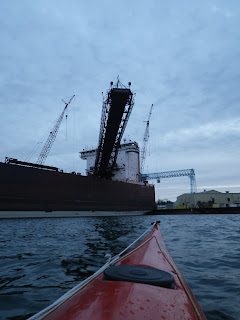
I had a light on, but didn’t know where they were going and suspected they might head into the shipyard…which they did after I had arrived back at the launch…I just didn’t want to be in their way, so I hurried the last several hundred feet past the 1000' Burns Harbor (boom repairs) and into the shelter of Sunset Park
Burns Harbor-boomed out
Nothing exciting, just an evening paddle to renew my soul.

Maybe I’ll get lucky in December too.

Wednesday, November 9, 2011

High Winds and High Cliff Canal


There have been several days of high winds (50-70 mph) here causing widespread power outages and downed trees. I knew there were large waves in Lake Michigan of over 25’, but I didn’t hear reports of shore damage. Just probably wasn’t watching the news at the right time I guess.

I launched at Sawyer Harbor in Potawatomie State Park about 10 miles by road or 4 miles by water from my home. I had sailed here several time this year and paddled once early in the summer. The moon was almost full and I’d thought a paddle around Cabot’s Point past the Sherwood Point lighthouse would be good this evening. The temperature was moderate for October. It didn’t take long for me to warm up, so we just kept going on to the High Cliff Canal, which is a man-made canal circling a small island surrounded by homes…probably a nice place to live. Some homes are large and others are fairly reasonable. It was about an 8 mile round trip on calm water.

Along the way I found several docks that had been damaged, moved around and twisted by the large waves a week or so before. Areas where the rocks had been scrubbed free of their usual green algae coating and newly fallen rocks that were beaten by water into submission and now were almost submerged.

I left about 5:30 and it was dark by the time I passed the Sherwood Point lighthouse on the return. The moon was rising on the left with the light house signaling on the right…sweet. Some powerboats were around mainly on the way out. Guys fishing earlier in the evening, but I saw only one boat after dark, so it was a quiet paddle home.  I stayed near the shoreline in shallow water after dark as much as possible to avoid being in any boats way.
The boat launch in Sawyer Harbor

Dock damaged by waves

Shoreline SW of Lighthouse

Entrance to the High Cliff Canal

Full moon over bridge on High Cliff Canal

Moon and Sherwood Point Lighthouse

Night landing in Sawyer Harbor


Saturday, November 5, 2011

GRINDING in October

I was grinding paint off the bottom of a sailboat, planning to repair the 30 years of dings, chips and gouges on the keel while laying on my back interlaced between the trailer frames and I’m interrupted by a phone call, several in fact. It was great weekend, near 60, almost calm, sunny and several friends wanted to paddle…one more paddle on a warm sunny day. I had to tell them, sorry I’d like to go, but I need to work on the keel of this boat while it was still warm enough to do some fiberglass work. That was funny I thought, the whole summer has slipped by and on the last day people are in a rush to get in some water time…summer is busy and it is hard to fit everything in. I want to go, but if I’m ever going to use this boat, I need to start the refit…maybe it will get in the water for a month or two next summer.


A week earlier, the evening before my daughter and I went to Kentucky, I paddled in town. That was a beautiful warm fall evening, calm, twilight, the full moon rose, just serenity at its best.

I had launched at Sunset Park and headed toward the Maple-Oregon Street Bridge or the MO Bridge as the operators call it. Passing Bay Ship Building, there were two guys in a pulling boat out in the mid channel of the shipping lane. I was passing them, heading closer to shore as it was dusk and I don’t like paddling away from shore in the evening light when a small kayak is difficult at best to see. The Harbor Lady had left the dock near the bridge a ½ mile away and was heading toward us. The rowers were staying in the channel and I mentioned to them it might be a good idea to head to one side or the other of the channel and stay out of the Lady’s way. They did meander over my way near the shipyard.

Kayaks are small, slender, low and sleek. Qualities that make them efficient to paddle, but difficult to see, even in daylight. When the light is low, I stay near shore. I bring a flashlight, strobe, rocket-flares and a light attached to my vest. Signalling devices are always with me.   Fortunately I have never used anything other than a light. If I ever need to bail out and then lose the boat, I’ll still have signaling devices with me instead of floating away on the kayak. Don’t know if the rowers had a light, but I turned on the jacket light and let it droop over my shoulder, so it wasn’t shining in my face, but would be obvious to a boat coming up from behind me. Another reason to drift near shore are treasures…treasures that escape from some poorly tied knot and become set free until they find me. Tonight it was a black 20” fender. I tied it on the rear deck.

There was a rhythmic clanging in the distance from behind…clack, clack, clack.., like a bell. I looked over my shoulder…a tug was coming up the channel with a flap on top of the exhaust to keep out weather and dirt when it was running. The flap was clanging with each puff of exhaust. A small harbor tug named Barry, a good simple name. I followed it and the Harbor Lady toward the bridges. Barry pulled in and tied up to the tugs of Selvik Marine Towing and I continued on past the MO and Center Point Marina on the left, then crossed the channel to the DNR dock and headed back, past the Coast Guard dock, Selvik, the Maritime Museum where I paused and tried taking a few photos of the rising full moon…didn’t worked so well. Low light, drifting boat in water=blurred photo.

So I paddle back in darkness and Moonlight. I have always enjoyed evening paddles. They are quiet, when the water is full of noisy craft running here and there during the day. The night is a quiet and peaceful time. A few lights here and there, stars, moonlight; I once paddled under the Northern Lights. The red and green flares are always amazing to see, but it is just rare to see them from a kayak….

Oh Yeah I was GRINDING…later.

Saturday, September 24, 2011

It's a Chilly Rain

So I’m sitting here at the pc reviewing my summer…looking at photos of spending time in Nova Scotia. Trying to review in my mind and with pictures, of where I paddled, sailed and canoed…what better way to spend a rainy morning on the eve of Fall?


I’m looking at photos and making notes, as I didn’t write down every place I paddled each time, but so far the count is; 40 trips ON THE WATER…none in the water, but floating with some type of boat. Most were in a Kayak, some canoeing in the spring, 5 sails in the Blue Jay and 2 sails on a Compact 19.

Exploring the Door

September 20th To the MO Bridge
September 10th Detroit Island
September 9th North Bay
September 7th Chambers Island
September 2nd Bay View Bridge to Ship Canal
Aug 28th Sail Peanut to Sturgeon Bay Quarry

Exploring Nova Scotia
Aug 9th Kayak Toddy Pond, ME
Aug 5th Kayak McNutts Island, NS
Aug 4th Kayak Shelburne Harbor, NS
Aug 1st Kayak Blue Rocks, NS
July 31st Kayak Hubbard’s Harbor, NS
July 31st Kayak Lower Prospect, NS
July 29th Kayak Tancook Islands, NS
July 27th Kayak Graves Island, NS
July 25th Kayak Meisners Beach, NS

Around the Door

July 11th Sail Peanut to Quarry
July 9th Sail to Green Island
July 7th Kayak to the Sturgeon BayYacht Harbor
July 3rd Mag and Dad sail around Dunlap’s Reef
July 3rd Kayak to White Fish Dunes
July 1st Sail in Sawyer Harbor
June 30 Kayak Sawyer Harbor
June 28th Kayak to Strawberry Islands
June 26th Kayak, Tennison Bay to Horseshoe Island and Eagle Bluff
June 25th Sail Sawyer Harbor
June 22nd Kayak to Big Creek from Sunset park
June 19th Sail Sawyer Harbor
June 18th Kayak in Sturgeon Bay
June 16th Kayak in Sturgeon Bay
June 14 Sail in Sturgeon Bay
June 13th Kayak in Sturgeon Bay
June 11th Kayak up Bay Shore Drive
June 9th Kayak in Sturgeon Bay
May 30th Kayak SB
May 25th Kayak Sturgeon Bay
May 20th Canoe Europe Lake
May 12th Geisel Creek Canoe
April 12th Geisel Creek-Canoe
April 7th Geisel Creek-Canoe
March 21st Geisel Creek-Canoe

It was better year than I thought…and it is not over.
Door County, WI is a wonderful place to live.

Maybe as the days become cooler, I’ll share some trips…I was too busy playing all summer to sit inside on a computer.

I moved up here in 1976 from the Chicago area to Play Outside. Too stuffy and crowded down there. I Worked OUTSIDE in the shipyards as a Ship-fitter until 1991. That was Dirty, Rough, Dangerous, Demanding, Fun, Exciting. I learned a lot there about problem solving as everything had to be custom fit. CAD was in its infancy and not that accurate…Working there was great in the fact that you received an assignment from the supervisor, if you did well, you were left alone and just did the job, the less questions you asked the boss, the more he liked it…just do the job and get another one. So that was great, I had a lot of freedom, it was just a dirty, dangerous, place…if you didn’t pay attention you’d get hurt. Burnt, hit by some piece of metal, grinding dust and steel shavings in the eyes, having to dodge have a pad eye you were pulling on with a jack because your partner didn't put enough weld on it, fall into a hole, cut by a tool. Not getting hurt was a combination of working smart and just staying lucky.  So now this story is wandering away from the water, but not far, the shipyard is ON THE WATER. I’m wandering because last week I saw a couple friends, at one time or another we were partnered in the shipyard…we were telling stories, practicing for the old man’s “Liars Bench”…that in ten years we’ll be on…sitting downtown, reminiscing, exaggerating our exciting personal histories.

Just to illustrate some of the danger is a story Rick told. There were several old tankers that plied the Great Lakes, the Amoco Indiana and the Amoco Illinois. I had a scare on the Illinois while walking in a dark passageway (made more dark as I had just been out in the bright sun)…I stepped into the passageway and my right leg found an open manhole that led to one of the water ballast tanks…it scared the *%& out of me as I dropped to my crotch when the one leg went down, wondering how far I was going! I can still remember that feeling.  There were a few scrapes down my leg from the metal studs the cover was bolted down to.  I was just little excited after that…back to work.
Anyway one of the boats was being scrapped and Rick was spending his days and weeks, burning the boat apart with a cutting torch. Day after Day…burning steel, monotonous.... All the fluids were supposed to have been drained from the piping and tanks. This day he had cut off a section of a pipe, and then went further down the pipe to cut off another length. When his flame blew into the pipe, it ignited a bubble of gasoline still inside, which exploded out the end of the pipe and in a fiery mass splashed back toward him off a steel bulkhead, covering him in burning gasoline. Rick thought he was literally going to be toast, but because everyday he was burning with a torch on lead painted steel, Rick was wearing a full face burning shield, respirator, full leathers, helmet, and gloves. That gas burned only on the surface of his leathers and melted the face shield down onto his skin, so he only received a few burns around the edge of his face…lucky. After he slapped it all out, he could not believe only his face was hot. Someone on the other side of the boat saw what happened and called the rescue squad, but Rick had already left by the time they were on the boat. Rick went down to the nurse’s office. She was preparing for a burn victim as he walked in…she told him they were getting ready for this guy who was badly burned and he would have to wait…Rick said that was me, I need some ice on my face…one lucky man he was and shortly back to work he went. That’s the only way to be…if ya worried all the time you couldn’t work there.

Enough sitting, I have to go play…the rain is stopping.

Monday, September 19, 2011

North Bay

North Bay is on the Lake Michigan side of Door County WI.

We all made it through the 1st crazy week of school with our sanity! Now what?…get outside!…Wednesday I had paddled to Chambers Island in the evening, returning to shore about dusk. Today feels like a sail…light winds, go somewhere new…so North Bay sounds good. 20 years ago I had sailed here. It was so shallow I had to pull the rudder and steer with a paddle. That incident is why I now have a kick up rudder, that when up, doesn’t hang down below the Skeg of the Blue Jay. All we need is 6 inches to launch or sail…just about what is at the ramp at the end of North Bay Road.

Left home about 3 pm with the Jay in tow. Stopped in Bailey’s Harbor to say Hi to Lucille and get a Waffle Cone of goodness at the Yum-Yum-Tree
The Weedy Shallow Launch at North Bay

After filling my belly with some sweetness I continued up County Q, to Woodcrest, to Old Stage Road, to Cty RD ZZ and on to North Bay Rd, to THE WATER.

Shallow…I had to break the trailer and let it hinge so I could gently slide the boat off. Not much wind, about 10 mph from the N, NE…but enough.
The launch from the water side
It was just the right amount of wind for some unique sailing and too shallow to lower the centerboard or the rudder. I headed off from the dock, following the shoreline west, then south and back east…During the next 2 hours I made one large circle around the perimeter of North Bay.

The wind was perfect. Light, but we still moved at 2 mph +-. I sheeted off the Main and Jib onto a broad reach, tied down the tiller and just let her go, standing up in the bow while she steered herself.

I could carve turns like a kayak by holding the mast and by leaning the boat one way or the other, she would do a gentle turn…had an hour of rudderless steering until we had to beat into the wind…the light wind, the dying wind. Across the mouth of the bay and to the edge of Lake Michigan. The soft, sandy bottom giving way to the rocky, green weed bottom near the lake’s beginning. I could have walked back and followed the line the skeg had left in the sandy white mud, back to the launch. Now we sailed past an old fisherman, wading in the shallows, and were in 10 feet of lake water beating to the North Shore toward some kayakers playing around near their home on Marshals Point. As I reached the yakkers and the North shore, the wind just about completely died. One of them paddled…ah, peddled over…he had a Hobie with its unique Mirage fin drive . We talked for awhile about the great weather and his fin drive system. I’m sure the boat and fin drive are great to fish with, but I wonder how comfortable the boat is when the wind is 20 and you are broadside to a 4 foot sea with an open boat and 50 degree water? For now, I’ll keep my enclosed, traditional sea kayak
Our Shadow in the shallow sea

I get many compliments on how pretty the lines of a Blue Jay are. Not many people recognize her type or know what a Blue Jay is when I tell them. Most know what a Lightning is, when I mention that a Blue Jay is the Lightning’s smaller sibling and designed by the same person, they see the resemblance. A Blue Jay is a training boat. Designed to carry an adult and 2 children. It was a perfect boat for us to have while the kids grew up. Launching at the nearest boat ramp, we had her loaded with beach toys and would just sail up to the beach, play on shore for a few hours and sail back. The kids could play in the sand and water and I would enjoy their company on land and sea.

The wind is Dead now. The fin powered kayak brought bad luck, no wind, so I sat on the bow, feet hanging over the side and paddled, not long…15 minutes or so and the wind was back enough to let the boat carry me home
Heading the rest of the way Home

Sunday, September 18, 2011

Unexpected Surprise

September 2, 2011

I had not paddled for almost a month…not since rounding McNutts Island in Nova Scotia while on vacation. Too busy back in my life…sent my daughter off to college the week after getting home, preparing and getting ready for the start of the new school year here and various other things that needed catching up.

Where should I go that I hadn’t been for a while? There was a chance of severe weather in the afternoon so I was looking for a simple sweet paddle. I hadn’t been to Strawberry Creek nor to the Sturgeon Bay Ship Canal for years.
I launched under the Bay View Bridge and headed across the Bay.

Then followed the shore to the South passing near shore side homes, going inside the lagoon at Strawberry Estates to see what interesting boats were docked there.

Another half mile and the mouth of Strawberry Creek.
The DNR has a Salmon egg collection station up Strawberry Creek.
They capture Salmon that return to spawn, gather the eggs and release fingerlings each spring to propagate the salmon population in Lake Michigan.
Further south at the canal entrance are old cribs and pilings from long ago.
Then we get to the modern steel sided lining of the canal itself.

I had gone about a mile into the canal and heard thunder in the distance…whoa...time to turn around. Heading back, I saw a critter swimming along the steel piling. At first I thought is was a common Muskrat, but it didn’t dive like they usually do when you come near…It was a gray squirrel…I have disliked squirrels ever since they chewed a hole in my daughter’s playhouse and built a nest in the attic. I had to rip out the ceiling and insulation to clear the smell….I hate squirrels…

This one was trying to claw its way up the steel lining of the canal. That plan wasn’t working, so I stretched out the paddle, let it climb onto the blade, then set the mean little beast onto the bow of my boat. Several times it ran at me hissing with bare teeth, I used the paddle as a joust to keep it at bay until I could ferry it over to the rocks on the other side where it ran off and hid without looking back…good riddance!
Attention Squirrel on Deck!
The storm front was approaching and the wind kept increasing, so I hugged the western shore until I came to the Bay View Bridge and crossed over to the launch under a sprinkling of rain.

The wind was blowing onshore and gusting into the 20’s. No lightning or thunder, so I paddled upwind, then drifted…or really flew downwind back to the dock, just steering.
Pulled up on the downwind side of the dock and managed to get out without letting the boat blow away.
Then carried it back to the truck and lashed it down…I was under the bridge, so the wind was swirling around rather than just blowing a straight line down on me.
I drove home as the rain stopped.  The wind slowed down in an hour and after downloading photos from the camera, I invited Jeff over to look at pictures from Nova Scotia.

Tuesday, July 26, 2011

From Porter Lake Provincial Park

7-26-2011
Chilly and overcast today…maybe mid 60’s. Hanging out my wet gear from paddling yesterday and writing.  Going to leave by noon…going where? Through Halifax to St’ Magarets Bay.
Rain is predicted tomorrow.

Out East 2011, Over to Nova Scotia

I left from the Middle.

From the Middle of the USA, to the Middle of the TransCanada Highway (hywy 17), to the Middle of Nova Scotia. From Latitude 45 in Door County to Latitude 45 in Nova Scotia

Leaving Friday about 6:30 AM and arriving in Porter’s Lake Provincial Park about 10 PM on Sunday. 42 hours of driving, and two rest stops. The first was at Samuel Champlain Provincial Park in Ontario, near Mattawa and Saturday night at a private camp near Bethel, Maine.

I stopped in East Orland, Maine to see if my old friends were still there. They owned the Whispering Pines Campground. My daughter and I first stayed there in August of 1998. We were on the road heading home and needed a place to stay…I had stumbled on an ad for them in Machias, Maine, called them up about 8:30 and they said just park alongside the house and pay in the morning as we would be arriving until later.. Anyway its was one of those places where you just feel at home…so we came back 6 more times over the span of 11 years.

Sandy and Dwight are retired now, getting ready the sell next year…hope the economy improves and they get a good price...

Porter Lake, NS. This is a brackish lake with a small tidal influence…8 to 10 inches.

I could just paddle here…don’t feel like driving much today.

Looking at the map, the bay near East Chezzetcook looked interesting, with islands and protected areas to paddle. So, I just followed the road that ran through the Town of E. Chezzetcook, south to Meisners Head at the mouth of Chezzetcook Inlet. There was a hiking trail and a beach, both on the seaside and the lakeside…again a trapped, brackish lake, like Porter Lake…was Meisners Lake. There were 3’ breaking waves on the beach…kids were surfing on knee boards.

I took a hike to the headland. I was a rough cobblestone trail…an ankle twister. Scrub spruce and cedar, washed and beat-up lobster traps lying around here and there. The headland was about 50 high of red dirt and gravel. To the west was a 100’+ headland…Story Bluff, with waves breaking at its base. I scared up a few cormorants and other birds…sorry, but I’m not a birder and didn’t have a close enough look to check it out in my book.

So back at the beach, the slope was gentle and thought I could launch there. The waves weren’t always breaking and weren’t steep. I Loaded the boat up and pushed out through the waves…was a blast, except the camera mounted on the rear deck flopped over, so I turned around and rode a wave back in to remount the camera, this time making sure I tightened up all the adjustment points. The kids on knee boards thought it was cool a kayak could surf. Launched again and headed to the bar near Meisners Head. I could feel some current pushing me around. The swells were about 3 or 4 feet, no breaking waves until they felt bottom, when they would rear up and break, so I stayed away from those areas. The boat felt lighter, more buoyant, being in salt water…I could feel a difference in how stable it was…slightly less as it was sitting higher. I guess that meant I could pack heavier gear if I was camping. I paddled around avoiding the breakers as I headed back to the launch. Ran a breaking wave right up the beach at full speed…that was a rush! Portaged over to Meisners Lake, thought I could wash off most of the salt and check out the Islands scattered around as well. At the east end of the lake of the lake, I pulled out and hiked along the seaside beach, finding more old lobster pots and fire pit remains from local parties. The waves were breaking on the rocky shore…It’s a change from fresh water…there is more power and it foams on the beach and the rocks or shore. Not that it is polluted…at home the site of foam on shore is a sure sign of pollution, but in the sea, here is natural.

Tuesday, May 24, 2011

Newport State Park

Friday I stayed at Newport State Park, Site 4 one of two that weren’t already booked for the weekend. I just needed to sleep in a tent. Have a FIRE, Hear the sound of WOOD and Water. I thought as long as I was going to Northern Door, I’d bring a canoe and see if anyone would join up for a tour of Europe Lake on Saturday.
On the Way...to Duck Bay
Hiking the 1.5 mile trail to site 4, I followed the shoreline, noting how it keeps changing over the years…the water level in Lake Michigan is still low, extending the shore of the park, not really a good thing as all the campsites in the southern, shallower area of the park are up to 100 feet further from shore, which now has a large growth of Phragmites and brush.

There was an immature bald sitting in a large pine along the shore, which I frequently scared up as the trail was near to the beach. Birds just have this routine of flying a few hundred feet ahead of you, being annoyed by your presence, flying ahead…over and over…kind of comical…on water or land, most do the same thing. The eagle cried out a few times with his shrill call.

Lots of lake flies made the spiders fat and content
I was planning on just chilling out at camp, read a book, sit on shore, enjoy the wildlife and sounds…I forgot the book at home, bummer. So I gathered lots of wood, for after dark fire worshiping. I did the routine…set up the tent, hung the pack and found a large flat rock on shore to lay back and listen…a flock of swans, wings making the air sing as they go by, Caspian Terns with their raucous cry, red-wing blackbirds, of course geese and seagulls are ever present on any shoreline, be it Island or Main. 
Mute Swan
Newport is isolated enough on the eastern tip of Door County so few motorized sounds pollute the air. Once in a while, you’ll hear a plane or a distant car.

I had quite a view…to the North was the remains of the Pilot Island lighthouse, with Detriot/Washington Island even farther and to the South was the tall white line of the Cana Island Light, probably a good 25 or 30 miles total from North to South. Fog on and off covered Pilot Island…fog was predicted tonight and it would be dense. Easterly was just 70 miles of fresh water.

Pilot Island
Cana Island


Duck Bay, where site #4 is located, was once the site of a logging camp and the remains of an old log crib dock still sit in the water.

Schooners would land here to pick up shingle and lumber…this would be a nice site to sail to in a small boat…it is well protected from the south and somewhat from the North. The shore has enough soft areas to pull out a boat without rock damage…maybe this fall, another sailing trip?

About 8 pm the fog started to move in and the fire was built. I Tried to burn my pants off with the heat, but the thin skin on my legs couldn’t take it and I had to back off. The fire lasted until 10. I crawled in the tent. About 3 am, the raccoons whirling and fighting over something caught my attention; waking me up…It was so foggy, I could see haze in the tent with a flashlight. A fish tug motored by about 6, sounding a fog horn several times. Thought it might be a good picture, but the fog was too thick, I could see Gravel Island, but no tug.


My usual camp breakfast of instant, no mess, no cleanup, no dirty dishes of Oatmeal was Easy!. Took down the tent, policed the site and headed back to the car….the fog was lifting and it was warm, 60 degrees, pretty nice for mid-May.


Indian Paintbrush
It was a short drive to Europe Lake. I had sent out an invite to paddlers, but it was short notice and didn’t expect to see anyone, so I was excited to see long-time paddlers Terrie and Craig. We chatted greetings a bit and launched our boats…a variety of boats. A short open deck Kayak, a short canoe and one sea kayak. Shallow water, near shore paddling, so little warm clothing was necessary. Our set up time was short. Europe Lake was formed when glacial debris separated Europe Lake from Lake Michigan 11,000 years ago.


A few miles in circumference, partially surrounded by Newport State Park, the private land is slowly being developed with large vacation homes…of course they need a view, so the shoreline is being cleared in front of most homes, but there are seldom any motorized boats. It is a nice place to paddle in spring and fall when the big lake is cold.

We paddled about an hour and 30, then headed our separate ways.


Sunday, April 10, 2011

Playing in ICE

The Bay Ice started breaking up this week and I had been watching for an opportunity to get out and push some Ice with the kayak. The weather forecasting has not been very accurate this week. Saturday was looking good on one day, and then changing to rain, wind and back again to less chance of rain on another.

The forecast rain for Saturday went south of us and we ended up with sun, 50 degree temperatures and 15 to 20 mph winds from the SE.

Rich and I met at Sunset Park where the ice had cleared from the beach.

There was a pretty large ice shove at the N end of the park, so we headed there first, bumping up to the ice and lying alongside.


Further north, the ice pack loomed. It had one small open lead which we ventured into about 100 feet before it closed up.

The whole pack was drifting at several mph and we were leery of getting caught if the lead suddenly closed up.  We didn’t stay there long, but pulled out and paddled south along the ice packs edge.
There were several channel marker buoys being pushed under as the moving ice ran them over.


The red buoy going under 
My old Selkie was great for running up onto the ice as the bottom was almost flat.  It was a blast to take a hard run at an ice shelf and slide up completely out of the water.  My current boat, a Sirius has a strong v-bottom and running upon the ice is not so fun, the boat will just layover...better to stay in the slush.

Crushed Can Buoy
Up close we could see that the green can buoy was significantly crushed, I was impressed!
Our trip rounded out by going to the Oregon Street Bridge then back along the shipyard. Most of the winter fleet has left, just the Walter McCarthy…in the graving dock, the Saginaw, John J Boland and the American Courage are still here. The Tug Mary Page Hannah was in the small graving dock and a Roen Salvage barge was in the floating dry-dock with sections of the bottom being replaced
Ore Carrier Saginaw
Roen Salvage Barge in floating Dry-Dock
It was a great to be paddling again, the sun was warm and the ice exciting.
There was a kayaker's pot luck that evening.
Warm food, good drink and a movie...Paddle to Seattle
A nice way to end the day.

Monday, March 28, 2011

Breaking Ice

On Monday it had warmed again to the mid-40's, so after work I took the canoe out to Geisel creek for another try at making it down to Dunes Lake.  The snow had melted where I put-in on Saturday.  I ran into several patches where the creek was still froze for 50 or 60 feet, so I took a run at it, slideing the canoe upon the ice. Pushing my way across, I sometimes broke through. 

I wondered how well the varnish would hold up to being scraped  and crunched by the ice.  It sure made a lot of noise and sounded destructive.  I know from kayaking in brashe ice that it will take a toll on the hull,s fiberglass if you ram it too hard.  After about 45 minutes the last turn of the creek before Dunes Lake was in sight and I could hear red wing blackbirds singing and the crackly, rasping sound of Sand Hill Cranes.  Two Osprey were eating the remains of a half frozen fish out of the lake's ice as I came into view.


There was an open stretch, free of ice, so I let the wind blow us down the lake a ways, then just sat and enjoyed the sounds of spring.


I arrived back at the truck about dusk, feeling refreshed from being out On The Water.

Little did I know that two days later we would have the largest snowfall in 122 years and I would spend 3 hours shoveling snow.