Sunday, June 24, 2012

Kayak Kewaunee Harbor and Shore

Calm to light wind from SW
4 hours, 15 miles


Rocky Launch on the Kewaunee River
I launched at 9 AM just to the west of the Hy-way 42 bridge, in Kewaunee at a small park with a boardwalk. After some searching, I spied a small, grassy area amidst the rocky shore to launch.

I had looked at Father Marquette Park, a one time beautiful, sandy beach, but now full of rotting Cladophora (Mermaids’ Hair)…as was the North side of the swimming beach south of the river entrance.

I found out later, the extreme southern end of the beach was clear of Mermaid’s Hair and would have been a great launch point. The public boat ramp on the west side of the Hy-way, North side of the river, across from where I did launch, was good too…no fee for kayakers at this time.
Kewaunee Harbor Entrance
I headed out to Sea to the sounding Fog horn and light a mile or so Off-shore. It was glassy calm, water in the 50’s, air 60’s. A ten minute paddle brought us out to the horn. Dozens of fishing boats were scattered about trolling for?? fish. I sat there in the calm water enjoying the waooooh of the horn and looking at the coast line a mile or more away. Just glassy calm. So calm that when waves rolled in from passing boats a quarter mile away, they just merged into the smooth water…it was dizzying.


 Off Kewaunee-Fog Signal/Light
Ok, I’ve done some contemplation, now what? I headed to 50’ clay banks 2 miles south of Kewaunee. I was leery of the boat traffic, but as I was broadside to them and the water glassy smooth I should be an obvious TARGET…to avoid. I was. The 6 or 8 boats that passed, all cleared by a ¼ mile. Surprisingly the beach was not covered with Mermaid’s Hair, so exiting for a leg stretch and camera reposition was not a wade through a stinky mess.
Erosion along the Banks S of Kewaunee

Paddling along the Clay Banks of Kewanee County was a nice change of scenery from Door County’s Dolomite Limestone. As I neared town, there was a couple launching kayaks…I wasn’t going to stop, but then saw the beach was clear and it would be a good place to get out and move the GO-Pro Camera. They had just launched when I arrived and What the Hey? It was Robin and Chuck! Two friends I had been e-mailing, but hadn’t seen for several years. They were going for a paddle up the North shore and invited me along and so we went, out around the Pier head Light and North along the shore about an hour to “Round-About-Rock”.

“Round-About-Rock”  3 miles N of Kewaunee
Paddling back we were surprised to see another yakker, well a yakker wanna be, as she did not have lifejacket, spray skirt or clothes suitable to being a mile offshore in 49 degree water. The Lake Michigan Mid lake buoy is recording 61 degree water, but water temperature on the Great Lakes is like the wind…use the forecast as general information and it is what it is where you are when you are there…got that? In other words, local conditions may or may not be aligned with the predicted forecast.

North side of the Kewaunee Harbor

At the inner Harbor, Robin and Chuck went back to their launch on a nice sandy beach and I went back to my rocky nook.

Once a Coast Guard Boathouse, now someone's Home

East side of Hy-way 42 Bridge
I bought a large bottle of water and scarfed down the Strawberry fritter and raspberry cheesecake stuffed something I had bought in Algoma on the drive down that morning. Exercise has it rewards…yumm.

Sunday, May 27, 2012

Milwaukee Urban Water Trail


"Land was created to provide a place for boats to visit." Brooks Atkinson

Urban Trails

Milwaukee is a 2.5 to 3 hour drive from Sturgeon Bay. I have been curious about paddling the Big city for years. I was taking someone to the Milwaukee airport on Sunday, so as long as I was going, why not bring the boat and do an Urban kayak tour?

After dropping my passenger off, a nearby Duncan Donuts was calling my name, so I stopped for a muffin and donut. There is an observation parking area on the North side of the airfield and I went over there to eat watch aircraft and look at the Milwaukee Urban Water Trail Map, trying to decide where to launch. A white pickup with kayak racks was sitting a few cars away. After finishing my snacks I wandered over, introduced myself and asked if he knew where a good launch was. He paddled the area quite a bit and knew the area well. Skipper Buds on the Kinnickinnic (KK) River was good and had free parking/launching. He also liked the Bruce Street Ramp, there was a fee, but it was in the center of the paddling areas. I had been looking at Bruce Street anyway and he confirmed that would be a good place to start. On the way to Bruce Street, I drove past South Shore Park on Lake Michigan and stopped for a look. Lots of free parking and a nice beach to launch from….about a 200 foot carry from the street to the launch. The beach I would launch from was covered with Zebra Mussels, but no beachers to bother. I’m not picky about launches, basically if I can walk to the water, it will work for me. I will keep the South Shore Beach in mind for another time.
The Bruce Street Boat Ramp in Milwaukee, WI
When I arrived at Bruce Street…it is a small two lane concrete ramp with limited parking. There is a cost…$6.75. You can wade into the water to enter the boat if you don’t want to launch off the ROUGH concrete, which is what I did. I am paddling a fiberglass Sirius, which has its share or scratches and try to not abuse it if I can avoid doing so.
Resting on a log at Bruce Street

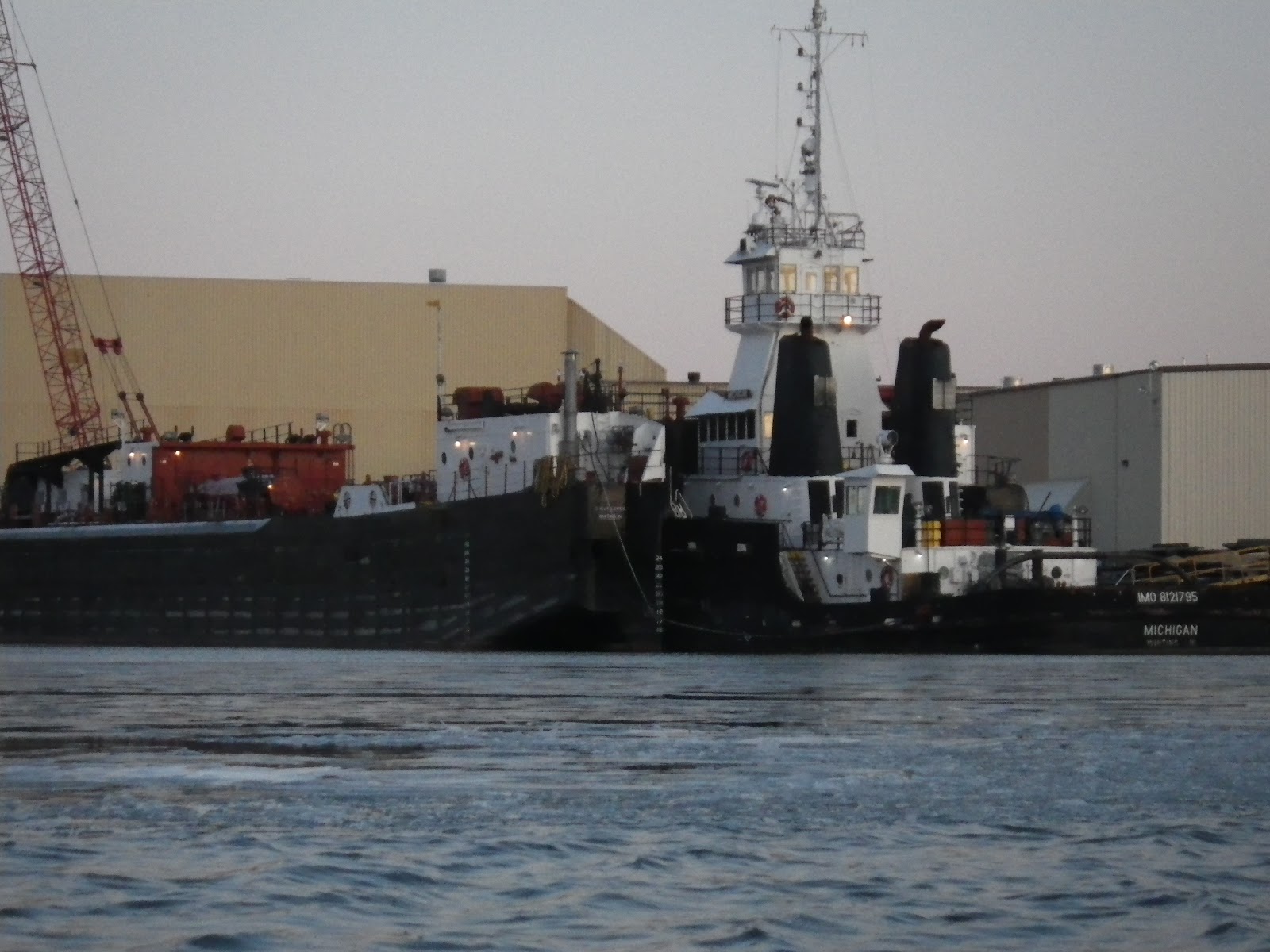
I did not have a particular destination in mind, I just wanted to see the area. I paddled South toward the KK River…Industrial is the word to describe the scenery. Steel walled docks, many different ships, tugs and barges.
Toward the Kinnickinnic River
After a mile or so I turned into the KK River…the scenery was more desolate, old dock materials and commercial buildings…graffiti…I continued up river, under the Lincoln Ave bridge and into Baran Park. The river now had green space with a natural shoreline, comforting to see. I made a short landing to adjust the GoPro mounted on the foredeck. I changed it from video to still shots and moved it aft of the cockpit, taking a photo once per minute. I swear there was a beaver house on the bank where I landed…a several foot high mount of sticks and mud about 10+ feet in diameter…beavers in the middle of a city? The next bridge at Chase Ave was inhabited, a squatter had a well hidden tent behind a piling and camouflaged with brush.   Shortly after the I-94 overpass the river is concrete lined and shallow…time to turn around…. Back tracking downriver, past partiers at Pier Milwaukee and Skipper Buds.
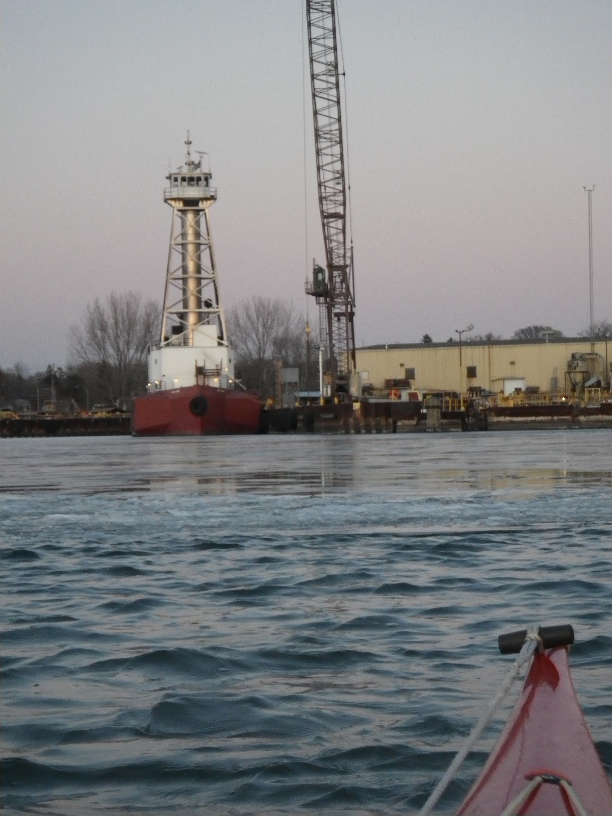
Southwest Marine Restoration

A security Guard at Southwest Marine motioned me over as I was photographing an old CG buoy tender sitting at their dock. The guard told about an old wooden boat that was going to be refloated on Monday…they had been restoring it in a floating dock. During WW2 it was used as a mine layer/spy boat disguised as a yacht and used behind enemy lines. After doing some research I didn’t find the name of this boat, but several boats of that type were built in Milwaukee during the 20’s at a Shipyard called Fabricated Shipbuilders for AMPS, the Army Mine Planter Service . At the next bend I was back in the industrial turning basin. Several tugs from the Great Lakes Towing Line were rafted up together.

Some tugs from Great Lakes Towing in Milwaukee, WI
Great Lakes Towing names their tugs after the US States and they are scattered over the ports of every Great Lake. Often a visitor to Sturgeon Bay was the Barge Integrity, blowing water out her forward ballast tanks and her tug, G. L. Ostrander, sitting in the notch.
Boat Recovery...powerboat style
After pumpout, use a forklift
Just South of the launch at Bruce Street the Coast Guard and a local Salvage Company were pulling a sunken powerboat from the water…maybe they had hit one of the many logs and pieces of debris I’d seen all day…only one side of the launch was usable because of several large tree limbs sitting in the eddy at the bottom of the ramp.

On toward the Milwaukee River…most of the old warehouses in the Third Ward have been converted into riverside condos with dock space. Milwaukee has done a cool job revitalizing the waterfront…it is clean, with a public walkway most of the way I paddled.

Canoe/Kayak launches have been incorporated into many of the docks near the restaurants and have steps down from the street, making it easy to stop for a meal. I don’t know what they have for sreet parking,  but support for all types of watercraft access and use on the Milwaukee River was exciting to see.

It was comforting to see a 5mph or no wake zone in the entire river and basin…most of the tour and personal boats I encountered were not moving any faster than I was.
Blurry photo of Tug Barry...sorry I was caught in a gust of wind

Last fall when paddling in Sturgeon Bay the Tug Barry motored in from Green Bay and headed through town…now it is docked in the Milwaukee River. I enjoy paddling in the swells and waves of Door County, but over the year I have paddled its 250 miles of shoreline several times over…this is just an interesting change of scenery and it is good to know that downtown paddlers have good support from the City of Milwaukee. I continued through the tall reflective building and past many waterfront restaurants, trying to not fixate on the wonderful tempting aromas…the donut and muffin I had before paddling was wearing off….I wish I had brought some cash!
Laacke and Joys on the Milwaukee River
Laacke and Joys was having a watercraft demo day, with kayaks, canoes, music and food at their waterfront store…It was nice to see many other yakkers on the river. A first time paddling couple in a canoe kept trying to ram me….3 close calls…not on purpose, but from lack of control. It was kind of funny and plastic boats don’t do much damage, we all had a laugh. At the next bridge I turned back downstream arriving at the Bruce Street about 3pm. A 3 hours sightseeing tour of about 10 miles. When given a chance away from structures the southerly wind was blowing over 25, so I’m glad there was shelter today.

Maybe Urban Tours are on the calendar this Summer


Saturday, May 19, 2012

It’s Just A Rumor


In mid-April...I went lookin' another boat and saw an ad for a Current Designs Rumor on www.paddling.net.

I contacted he owner and made arrangements to try it out. He lived a few hours away so I drove down on a Sunday afternoon in mid April for a test paddle.

Nice, looking traditional lines…16 feet by 19.75”. Tried her out on land and the cockpit was narrow. It was only 14.5” wide by 24" long. They call it a modified ocean cockpit. There was some light chop with about 1.5 to 2 foot waves on Lake Winnebago. I didn’t want to scratch the hull on the rocky beach, and so waded out into a few feet of water and cowboyed in. A little dicey with the narrow cockpit and narrow beam. As I slid into the cockpit, the backrest folded down onto the seat and the spray skirt was caught under me as well. With the cockpit only 14” wide there wasn’t much room to get a hand down to the seat and pull up the backband and skirt, especially doing a balancing act in the choppy water. Anyway I managed to get everything in place and paddle around for 30 minutes, did a little surfing, tried the skeg; found a few breaking waves to blast through near shore went up and down wind. I liked the way the boat handled. It wasn’t too unstable with that narrow beam, but I kept thinking about the narrow cockpit. That could present problems during a reentry and roll or a paddle float entry, especially if it was rough. Even landing/launching on a beach with breaking waves would be tough getting out quickly. I did not want to just run up on the beach and jump out as the boat was basically like new and it wasn’t mine, so I popped the skirt before landing and managed to get out just before the beach. Well sort of fell out. I had a Valley boat with an ocean cockpit for 20 years…that cockpit was several inches wider, but shorter and for me it was easy to enter or exit…anyway I passed on the boat for the cockpit. If I had bought it, I’d replace the cockpit with a keyhole type. It is still in production, but with that small cockpit, I can't imagine it sells very well.  The dealer Ross bought it from had it in stock for over a year.  Now I'd like to try a Romany.

Sunday, April 1, 2012

Steel Ships and Spring

Waiting to leave after some winter R and R

Back in February
Over several weeks in March the acrid smell of bunker fuel and the wail of ship horns signaled the start of another shipping season. Two weeks ago as I paddled to the Mo Bridge from Sunset Park, several ships were smoking steam, soot and moaning…sounds from some auxiliary machinery running down in the bowls of the steel hulls, warming up the habitable spaces, generators running, testing gear and such.

There is a local ordinance that a ship can only produce heavy smoke for 7 minutes each hour, I think left over from the coal and heavy fuel days...now that seldom happens although you can detect the unusual smell of burning oil once in a while as the boats fire up.  Most are diesel powered and a few still have steam turbines, but many have steam boilers for heating the populated spaces.

Anderson and Callaway
The Arthur Anderson was spiting steam, the prop wasn’t turning, but it was twitching…every few seconds moving an inch, so as I was doing a little photography I took care to not get too close.

The steam turbine powered Wilfred Sykes 
During the following two weeks, most of the fleet left…

I watched 6 leave on a drizzly Friday evening,
several more over the weekend. Currently about 6 ships are still in port.


Sharing water with the Big Boys

Now that the ICE has melted, I'll probably do some canoeing on the few local creeks...It is just simpler to get out on the water after work, I don't need the drysuit as I'm a few feet from shore and the water is only waist deep.  I guess, without the ICE to play in...it's just COLD water to me, to kayak now, means wearing a drysuit with many layers and feeling stiff and clumsy while paddling...I'll just let Lake Michigan and Green Bay warm some while I go creeking in a canoe and continue work on the Trap Skiff when I'm not Outisde.

Two Weeks ago I hung the Sheer Plank on the Trap Skiff, so the planking is finished.  So the hull is whole, but the boat is probably only a third complete. 
Trap Skiff...hull done!

Sunday, March 18, 2012

Potawatomi State Park, Sturgeon Bay, WI

March 16th, 2012
Looking North toward the Bay of Green Bay
Crazy warmth this week, 60’s even touching 70! On Monday the Coasties were out in the AIR and on the SEA after a report of two 4 wheelers abandoned on the ice near the Old Stone Quarry…it turned out to be two sunk and busted up ice shanties…chalk that run up to practice. Almost 20 fishermen have been rescued this winter because of the unstable ice conditions. Two weeks ago, after a strong 30+ mph wind from the SE blew for a few hours, an open lead started from Egg Harbor down to Dykesville, probably 30 or 40 miles long in what was solid ice…it is amazing what the wind can push.


I been watching the weather and waiting for the wind to die, but I’m almost finished planking the Trap Skiff…just the Shear Plank left and I want to finish this weekend, so what to do? Paddle; walk, or work on the boat? The weather was too perfect and the ice is melting fast so I went over to Potawatomie State Park looking for ice late Friday Afternoon…Sawyer Harbor was Ice free, but there was pack ice floating a quarter mile off shore between Potawatomi Park and Sturgeon Bay.

I launched on a cobblestone beach just North of the old boat ramp
 on the East side of Potawatomi State Park and headed toward the ice.
Red Nun #26 in ice
Warm, bright sun, the air was 60 degrees and the water 33. I pushed into a few leads, they were mostly so rotten the ice just crumbled under the hull, on some I rode up out of the water, and then sank back in. A Red nun buoy was cleaving the pack ice as the light wind moved it down upon the buoy. I Paddled about an hour, just poking around, the water was extremely clear, a lack of debris with no algae and lots of sun shining right down to the bottom …I could make out every detail on the lake floor 10, 12 feet below.

Looking toward Sturgeon Bay and the Ship Yard
That was refreshing, sometimes May isn’t this warm!
The next day...the ice was gone.

Saturday, March 17, 2012

Lilly Bay Boat Launch to Whitefish Dunes to Cave Point

Kayak Feb 4, 2012

Whitefish Dunes State Park
Back on Feb 4 It was supposed to be up to around 40 degrees and it was.

I had wanted to finish hanging the 4th pair of planks on the Trap Skiff before I thought of paddling. A friend stopped by to look at the skiff on Saturday, so he was a welcome helping hand as I finished off the rabbit on the bow, then glued up the surfaces, hung the plank and fixed the 50 or so clamps along the 20 foot plank.


After finishing the plank, it was lunchtime and then I checked the weather forecast. Wind about mid teens from the west and temperature in the low 40’s….If I went to the Dunes or Cave point, then I would be on the eastern lee shore of Door County…perfect, little wind and few waves…I didn’t really want to be in any waves when the water is what 33 degrees?

After rounding up the gear and getting dressed for the cold I made it into the water about 3:30. Launching at the Lilly Bay Boat Ramp a few miles S of Whitefish Dunes State Park on Lilly Bay Road.

It is about a 2.5 mile paddle along the pure sand beach, then the shore becomes rocky until Cave Point where there are a few caves to paddle in if the water is calm, otherwise you might get a headache if you enter as there is maybe 2 feet of clearance above your head.

West winds about 15. I was on the East side of the Door Peninsula and so was in the lee of the land. As long as I stayed within a quarter mile of shore, it was pretty calm.

Air, mid forties when I left at 3:30 and near freezing at 5:30 when I took out.
The Lilly Bay Boat Ramp


The boat ramp at Lilly Bay is sanded in so only hand launched boats can use it. Since the water levels of Lake Michigan fell ten years ago the ramp has been unusable for trailered boats.

Waves were less than 2 feet, some breaking waves near shore and the shallow areas.

Pretty nice for February! No shore ice at all.

So I poked along shore, did some surfing on the breaking waves occasionally as I paddled along the 2 mile sand beach toward the Dunes. I tried to go up Whitefish Dunes creek which flows from Clark’s Lake, but it just wasn’t deep enough and I grounded into the sand. The water is so much clearer in the winter…most of the summer the cladofera are pooled near the northern portion of the dunes beach and as summer progresses that part of the beach is unusable and avoided because of the smell of decaying vegetation…rip currents often form toward the northern end of the beach and swimming is prohibited in that area as several people have drowned.
Beginning of the rocky shoreline
Continuing North, the shore is increasingly rocky with the land gaining in height. The limestone Cliffs of 20 or 30 feet are rare on the east side of Door County. Lake Michigan has eroded and beaten caves into the limestone, several of which are large enough to paddle into on a Calm day…I never enter a sea cave if there is wave action…helmet or not...I love my life.

Along the cliffs of Cave Point County Park ice was dripping down the rock face,… which I had hoped to see. I don’t care for cold water, so seeing the lake in winter as a different environment from summer motivates me to paddle in the cold. Most years the weather is not conducive for winter paddles…too much shore ice and temperatures way below freezing so ice is forming on your boat and gear…that is not for me.

 I posted this 6 weeks after I paddled…I’m bad…I just want to paddle and play

Saturday, January 7, 2012

Paddle from Portage Park to Sturgeon Bay Canal Entrance Light

This weather has been wonderful. I have been able to get on the water several times during the past month.

Tug Michigan and Barge at Bay Ship.

Hope this keeps up. The past 4 winters were bad, with record breaking snow totals each year and cold temperatures. Last year at this time, we had 30 inches of snow, wind and frozen water everywhere.
Tug Oliver Moore, built in 1928
Now Sturgeon Bay is iced over, but not very thick. I launched at Sunset Park on Christmas Eve  and  Sawyer Park on the 30th for a trip to Bay Ship and back. Late on January 6th, I was able to get out to Portage Park with enough time for a trip to the Ship Canal Entrance Light before darkness took over the short day.
Portage Park to Canal Route

Portage Park to the Sturgeon Bay Ship Canal entrance

Sturgeon Bay Entrance Light

Portage Park
Living here in the Midwest when winter arrives, the water freezes except out in open Lake Michigan. Usually it is difficult to find a decent place to launch because of the shore ice which can be a jumbled mess several feet thick.


Maybe the mild weather will keep up and we can get out next month just as easy too.